Contact-free structural inspection and corridor survey
With systems carried by drone or helicopter, we inspect structures as well as corridors, overhead lines and transport routes efficiently and without interrupting operations. You receive high-resolution close-up images, centimetre-accurate point clouds and structured 3D models for complete documentation of damage and condition and for thorough analyses.
Key facts
What we inspect from the air
The drone does not replace a specialist. It takes their view to places that are otherwise difficult to reach.
Bridges and engineering structures
From close range we capture load-bearing structures, bearings, piers and soffits at millimetre resolution. Cracks, corrosion damage and concrete spalling can be documented reliably and compared over time.
A good fit for Construction & InfrastructureOverhead lines and lattice towers
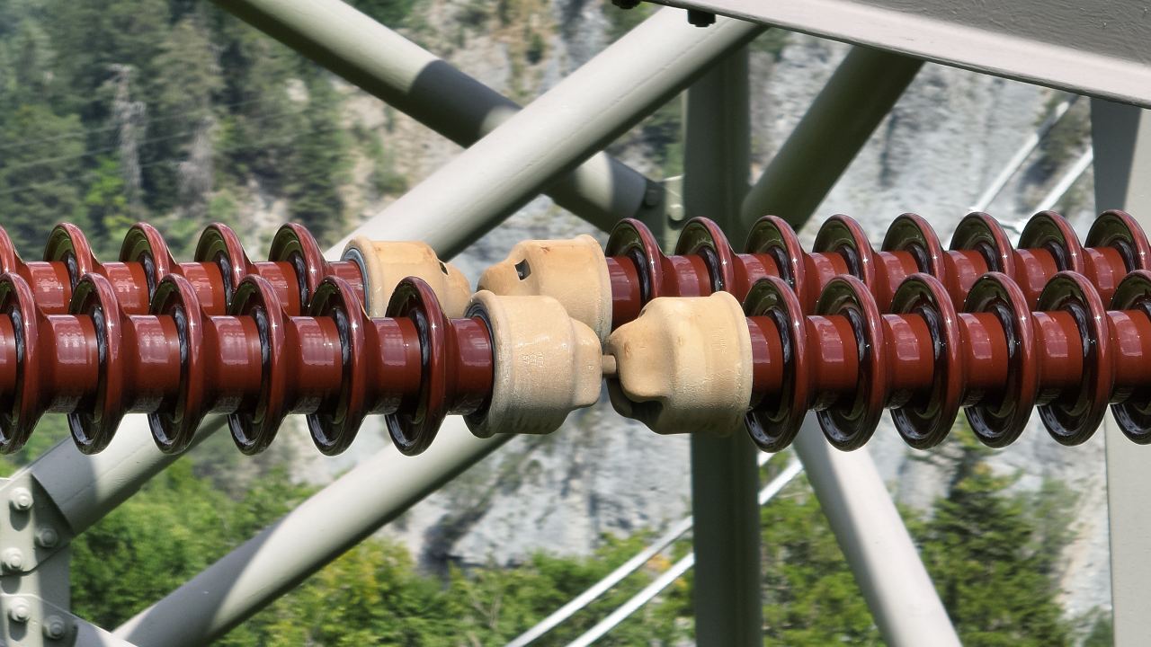
High-resolution close-ups document insulator strings, clamps, dampers and tower structures without switching off the line. Damage from lightning strikes, wear or deformation becomes visible early.
A good fit for Construction & InfrastructureRoute and corridor mapping
Along railway lines, roads and energy corridors we capture the geometry and the surroundings continuously in a single flight. Point clouds and orthophotos provide the basis for clearance gauge checks, conductor sag and distances to vegetation.
A good fit for Construction & InfrastructureBuilding envelopes and industrial plants
Inspections of roofs, facade junctions and technical installations without lifting platforms or scaffolding. Combined with thermal images, we also detect defective photovoltaic modules, insulation faults and moisture ingress.
A good fit for Construction & InfrastructureProtective structures and steep terrain
In rough terrain we capture rockfall protection nets, avalanche barriers, rock faces and erosion gullies without contact. The data allow safety checks and deformation monitoring after extreme weather events.
A good fit for Environment & NatureDams and hydraulic engineering
Dam walls, pressure pipelines, weirs and bank protection structures are digitised with exact geometry and without interrupting operations. Cracks, settlement and erosion at close range can be monitored with engineering survey methods.
A good fit for Construction & InfrastructureImpressions from our projects


What you receive from us
We hand over structured, georeferenced image and geodata for direct integration into your maintenance and inspection management systems.
- Calibrated series of detailed images: high-resolution close-ups of the relevant components and damage, including exact geotags and metadata on the viewing angle.
- Geometric 3D basis: dense point clouds, textured 3D meshes and dimensionally accurate orthophotos of the structure for precise damage mapping.
- Corridor and route data: complete capture of linear infrastructure, with clearance profiles, distances and conductor sag that can be derived from it.
- Repeatable time series: standardised flight paths for consistent follow-up flights, for reliable monitoring of cracks and deformation.
- Complete permit management: obtaining all aviation approvals (FOCA, SORA) and coordinating the operation with infrastructure operators and authorities.

Technical details
We define the values together with you for each project.
| Platforms | Industrial multicopters for individual structures and point objects, helicopters for large corridors and high-voltage lines |
|---|---|
| Sensors | High-resolution medium-format and full-frame RGB cameras, high-precision LiDAR with multiple echoes and radiometric thermal cameras |
| Image resolution | Up to 120 megapixels per image, for detecting cracks below a millimetre from a safe flying distance |
| Ground sampling distance (GSD) | Millimetre range on components and facades, down to the sub-centimetre range on corridor flights |
| Delivery formats | JPEG and TIFF with geotags for image series, LAS, LAZ and E57 for point clouds, OBJ, FBX and 3D Tiles for models and GeoTIFF for orthomosaics |
| Coordinate system | Swiss national coordinates (LV95 with LN02 or LHN95), railway reference (LV95 SBB) or local structural networks |
| Interface and analysis | Delivery of dimensionally accurate primary and 3D geodata for the technical condition assessment by structural engineers, plant operators and appointed experts |
How a project works
From the first exchange to the finished geodata in your system.
-
Advice and quote
Draw your project area directly in the quote form or describe your requirements. Together we define the optimal resolution and the scope of services for your project.
-
Planning and flight
We match flight pattern, overlap and ground sampling distance precisely to the required target accuracy. Data is captured efficiently with our professional flight and sensor technology.
-
In-house processing
Aerial triangulation, classification and 3D modelling run entirely on our own high-performance computers. Even large perimeters with tens of thousands of images are processed with complete consistency and reproducibility.
-
Delivery and proof
You receive ready-to-use geodata, tailored exactly to your coordinate system, your software and your tiling requirements, including transparent proof of accuracy.
When an inspection from the air makes sense
Drone-based structural inspections provide a complete visual record of exposed structures and identify damage before inspection teams go on site. They reduce risks for people, save the cost of scaffolding and avoid closures during operation.
Well suited
- Tall, hard to reach or extensive structures such as bridge piers, chimneys, lattice towers or dam walls.
- When expensive scaffolding, lifting platforms, rope access or track closures are to be avoided.
- Inspections of lines, transport routes and industrial plants without interrupting normal operation.
- Standardised comparisons of images and geometry to document the progress of cracks and changes in materials over time.
Less suited
- Investigations that require sounding the concrete, ultrasonic measurements, probing the reinforcement or material samples on site.
- Components without a clear line of sight or areas with extremely confined interior geometry.
Frequently asked questions
Does a drone inspection require a permit?
Yes. Demanding flights over infrastructure or in built-up areas require a sound legal basis. We operate with an authorisation from the Federal Office of Civil Aviation (FOCA) in the «specific» category, based on SORA risk assessments. Additional clearances in the control zones of aerodromes (CTR), at high-voltage lines or along railway lines are obtained in advance directly from Skyguide and the respective operators.
Does the drone replace the main inspection?
The drone does not replace the judgement of the engineer in charge, it provides the complete image and geometry basis for that judgement. It serves as a highly efficient preliminary inspection, documents damage at millimetre resolution and pinpoints problem areas. Hands-on inspections or openings in components can therefore be reduced to what is strictly necessary.
Can you also capture thermal images?
Yes, we use radiometric thermal cameras to record anomalies in building physics and technical installations. Typical applications are the detection of hotspots on photovoltaic plants, locating leaks in district heating pipes and finding thermal bridges and damp areas in building envelopes.
How can conditions be compared over the years?
Using precise real-time kinematic (RTK) waypoint control, we fly repeat inspections with exactly the same camera positions, viewing angles and focal lengths. The resulting images and 3D geometries can be overlaid directly in specialist systems, so that cracks, corrosion and deformation of components remain quantifiable over the years.
Which data does your project need?
We advise you without obligation and show which services and which platform suit your project.