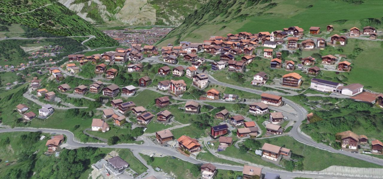
Up-to-date, textured 3D city models
A 3D city model divides the built environment into separate building volumes with differentiated roof shapes at level of detail 2 (LoD2). We create new models from current survey flights and point clouds or update existing datasets, on request with finer roof structures such as dormers and chimneys and with photorealistic texturing of facades and roofs.
Key facts
What you use a city model for
As semantically structured 3D building volumes, city models are far more than just a visualisation. They serve as a reliable geometric basis for spatial analyses, statutory checks and well-founded simulations.
Land use and zoning planning
Planned construction projects can be fitted directly into the real building stock. Building heights, boundary distances and total volumes are visualised early on and checked for how well they fit into the neighbourhood.
A good fit for Government & AuthoritiesSolar potential
Pitch, orientation and the real roof geometry determine the yield of photovoltaic systems. Dormers, chimneys and other roof structures go directly into the calculation as obstructions to be deducted and into precise analyses of self-shading.
A good fit for Government & AuthoritiesNoise, wind and shadow
Propagation simulations need closed, mathematically clean building volumes and roof surfaces. The LoD2 city model provides the reliable input geometry for noise propagation calculations, fresh air corridors and solar radiation studies.
A good fit for Construction & InfrastructureUrban climate and heat islands
Combined with terrain heights, tree stock and the degree of soil sealing, the city model forms the basis for thermal analyses of neighbourhoods. Planners identify overheating zones in a targeted way and designate effective areas for greening and shading.
A good fit for Environment & NatureDigital twin and specialist platforms
As a binding data basis, the city model brings together specialists from building administration, surveying, utilities and external engineering firms. We deliver the data in exact conformity with your municipal data model and target system.
A good fit for Government & AuthoritiesPeriodic model updates
We update existing city models specifically with new buildings, renovations, added storeys or demolitions. Existing object IDs and attribute structures are fully preserved, so your database continues seamlessly.
A good fit for Government & AuthoritiesImpressions from our projects


What you receive from us
You receive a semantically structured, georeferenced 3D city model based on current survey flights and laser scanning (Light Detection and Ranging, LiDAR), seamlessly linked with official building footprints or your own records.
- City model at LoD2: individually addressable building solids with differentiated roof shapes and stated eaves and ridge heights
- Detail at LoD2+: modelled roof structures such as dormers, chimneys, lucarnes and roof windows for precise analyses
- Block model at LoD1: simplified box models for a quick assessment of spatial planning and large-scale massing studies
- Semantic links: direct connection to specialist data and official registers such as the Swiss federal building identifier (EGID)
- Photorealistic texturing: high-resolution facade and roof textures from oblique aerial images, also as an upgrade for existing models
- Connection to the terrain (DTM): every building meets the ground exactly, using a digital terrain model derived from the same flight
- Proof of quality: documentation of the source data, the date of capture and the geometric accuracy

Technical details
We define the scope, level of detail and formats together with you for each project.
| Source data | High-resolution aerial images and LiDAR point clouds from our survey flights, captured by drone, helicopter or aeroplane |
|---|---|
| Footprints | From the official cadastral survey, from cantonal geodata, from swissBUILDINGS3D or from your own record plans |
| Levels of detail | LoD1 (block model), LoD2 (differentiated roof shapes) and LoD2+ with dormers, chimneys, lucarnes and roof windows |
| Perimeter size | Scalable from a single building complex through neighbourhoods to entire municipalities and cities |
| Model updates | Targeted integration of new buildings, conversions, added storeys and demolitions while keeping your existing schema |
| Texturing | High-resolution roofs and facades from calibrated survey flights, also as a visual upgrade for existing vector models or swissBUILDINGS3D |
| Delivery formats | Standardised city model formats (CityGML, CityJSON), CAD and BIM formats (DWG, DXF and Industry Foundation Classes, IFC) and streamable 3D Tiles and scene layer packages (SLPK) for web viewers and GIS |
| Coordinate system | Swiss national coordinates (LV95 with LN02 or LHN95), railway-specific (LV95 SBB) or global coordinate references such as WGS84 |
| Intended use | Spatial and zoning planning, solar potential analyses, microclimate simulations and municipal digital twins |
How a project works
From the first exchange to the finished geodata in your system.
-
Advice and quote
In the quote form you define the perimeter, the level of detail (LoD) you need and whether the model is created from scratch or updated. We incorporate existing geodata and footprints directly into the needs analysis.
-
Flight planning and data capture
We capture the project area with aerial images, LiDAR or a combination of sensors. We match the flight parameters and the ground resolution precisely to the accuracy required for the roofscape.
-
Modelling and quality assurance
From point clouds and footprints we construct closed building volumes with precise roof geometries. Every building undergoes a strict geometric plausibility check, including manual rework of complex junctions.
-
Delivery and periodic updates
You receive the consistent 3D city model in your native GIS or CAD formats, accurately referenced in the Swiss national coordinate system. We reliably add future structural changes to the same dataset.
When your own city model pays off
With swissBUILDINGS3D, the Federal Office of Topography swisstopo provides a nationwide base model. With a positional and height inaccuracy of 30 to 50 centimetres, without roof structures such as dormers or chimneys and with an update cycle of several years, it is primarily suited to large-scale overviews. Binding planning, building applications or precise solar potential analyses at the level of individual components require a true-to-scale, up-to-date survey.
Well suited
- The model should show the built state as it is today, for example after new neighbourhoods or larger developments have been completed.
- Characteristic roof structures such as dormers, chimneys, lucarnes and roof windows have to be represented with geometric precision in the model.
- Buildings should be available as individually addressable objects, so that solar potential, total volumes or environmental simulations can be analysed automatically.
- An existing municipal or cantonal model is to be updated periodically without changing the existing data schema.
Less suited
- For large-scale visualisations with no requirements for currency or small structures, the base dataset of swissBUILDINGS3D is entirely sufficient.
- The focus is on the organic appearance of trees, terrain edges and textures, for which textured 3D meshes or Gaussian splats are better suited.
- You are planning conversions or renovations with a focus on wall thicknesses and interiors, for which building modelling true to deformation is the right choice.
Frequently asked questions
What does LoD2 mean?
LoD stands for level of detail. While LoD1 shows buildings as schematic blocks, LoD2 shows the real roofscape with ridges, eaves and roof pitches. LoD3 would also show windows and openings in the facade, which requires surveys from the ground.
What is «LoD2 plus»?
LoD2+ extends the standard with architectural details such as dormers, chimneys, lucarnes and roof windows. These structures are crucial for solar potential and shading analyses, because they reduce the usable area.
Can you update our existing city model?
Yes. We adopt your existing data schema including IDs and attributes and add new buildings, conversions or demolitions seamlessly. Your model remains historically consistent and directly comparable.
Where do the building footprints come from?
From the official cadastral survey, cantonal geodata, swissBUILDINGS3D or your own record plans. We incorporate existing footprints directly to guarantee an accurate fit with your specialist data.
Do you need photogrammetry or LiDAR?
The two methods complement each other. LiDAR penetrates dense vegetation and provides precise terrain heights. For the highest geometric precision we often evaluate aerial images stereoscopically, capturing roof edges and eaves to the centimetre through manual image measurements at sub-pixel level.
How does a city model differ from a 3D mesh?
A 3D mesh shows surfaces, trees and structures as a continuous, photorealistic mesh of triangles. A city model consists of individually addressable, semantically structured building volumes for GIS analyses and simulations.
How accurate is the model?
The geometric accuracy is typically in the range of a few centimetres. It depends on the sensors, the flying height and the quality of the original footprints. We document the tolerances achieved transparently in the test report.
Can the buildings be textured?
Yes. From calibrated oblique aerial images we create textures for facades and roofs, also as an upgrade for existing models or swissBUILDINGS3D. The output is streamable, as Cesium 3D Tiles or as an ArcGIS scene layer package (SLPK).
How often should a city model be updated?
That depends on building activity. Cities with strong development update annually or every two years, others every few years. What matters is a methodically consistent continuation in the identical data schema.
Which data does your project need?
We advise you without obligation and show which services and which platform suit your project.